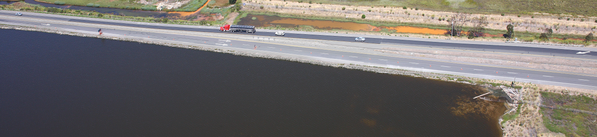
State Route 37 (SR 37) passes through the expansive marshes of the North San Francisco Bay, providing commuters, tourists, and trucks a path between I-80 and highway 101. It is in jeopardy of becoming flooded more often because of sea-level rise. This project involves stakeholder process and technical analyses to determine possible future planning solutions for the highway and its human and natural environment.
California State Route 37 is threatened by sea level rise from climate change, and traverses the largest remaining San Francisco Bay marshlands, which are similarly threatened by sea level rise. These North Bay wetlands contain endangered species and habitats, and are now undergoing active restoration. The congested transportation corridor provides North Bay communities with goods movement, commuting, tourism, and recreation. It also passes through one of the most economically-depressed communities in the Bay Area. Caltrans is actively conducting “corridor planning” for SR 37, this project will inform that planning.
The first phase of this project was funded by the Transportation Research Board, Strategic Highway Research Program 2, and supported a collaboration among Caltrans District 4, the Road Ecology Center (UC Davis), the Sonoma Ecology Center, Southern Sonoma County Resources Conservation District, Sonoma Land Trust, and Napa County Resources Conservation District. We studied ways that transportation planning for this highway corridor could be based upon stewardship principles and meet Caltrans' triple bottom line: preserving the environment, supporting a robust economy & promoting transportation equity. The second phase of the project was funded by Caltrans and focused more on the impacts of sea level rise and adaptive actions to reduce those impacts. This study signals a long-term commitment by Bay Area transportation and environmental agency partners and resources protection agencies to collaboratively finding a context-appropriate solution to the challenges of building in extremely sensitive environments and accommodating the changes that may come with sea level rise from climate change.
The project involves a collaborative ecological stewardship approach, rather than the typical project-based permit-and-mitigate approach. Stakeholders are meeting with the project team to discuss the benefits from the transportation system, impacts to the environment, and impacts and benefits to surrounding communities. GIS modeling approaches and valuation of ecosystem services and transportation are being used to compare among different possible scenarios for the highway. These scenarios include: continuing business as usual maintenance, armoring and raising the highway on fill, or elevating the highway onto a causeway. Caltrans and the Road Ecology Center welcome your participation in this process.